
Children's Map of the United Kingdom and Ireland
No Customer Reviews

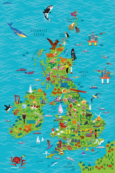
Colourful Illustrated Map of the United Kingdom and Ireland This highly illustrated, rolled pictorial map is designed to take children on a journey of discovery around the United Kingdom and Ireland. Stunning illustrations are used to depict themes such as national emblems, customs, food, birds, animals, buildings and sports to help younger readers gain an understanding of peoples around the world. Illustrated by Steve Evans.
Format:Paperback
Language:English
ISBN:0008212082
ISBN13:9780008212087
Release Date:July 2017
Publisher:HarperCollins UK
Length:1 Pages
Weight:0.22 lbs.
Dimensions:1.5" x 24.0" x 36.0"
Age Range:4 to 8 years
Grade Range:Preschool to Grade 3
Customer Reviews
0 rating
Copyright © 2025 Thriftbooks.com
Terms of Use | Privacy Policy | Do Not Sell/Share My Personal Information | Cookie Policy | Cookie Preferences | Accessibility Statement
ThriftBooks ® and the ThriftBooks ® logo are registered trademarks of Thrift Books Global, LLC
ThriftBooks ® and the ThriftBooks ® logo are registered trademarks of Thrift Books Global, LLC
